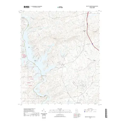
2020 Map of Bartletts Ferry Dam
USGS Topo · Published 2020About this map
Bartletts Ferry Dam anchors this landscape at the border of Georgia and Alabama, where the Chattahoochee River forms Bartletts Ferry Lake and Lake Harding. The area is characterized by significant topographic relief, with Pine Mtn, Williams Mtn, and German Mtn rising above the river valley. Local community life is centered around the small settlements of Mountain Hill and Piney Grove, along with several historic local sites. Genealogists and historians will find notable markers of the region's past at the Antioch Church, Antioch Cem, and Old Smyrna Cem. The intricate shoreline of the reservoir creates numerous islands like Cooks Island and Herrington Island, while the interior is drained by Mountain Oak Creek and Mulberry Creek. The map shows a transition from structured residential developments near the lakes to the wooded, mountainous terrain of the Harris County interior.
Find a feature on this map
86 named features on this map. Tap any name to fly to it.
Don’t see what you’re looking for? This feature index may not catch every label — zoom into the map to look around manually.
Map Details
Editions of this 2020 Bartletts Ferry Dam Map
This is the sole edition of this map. No revisions or reprints were ever made.
Other maps of this area

1907 · Talbotton
USGS Topo · 1:125,000

1907 · Opelika
USGS Topo · 1:125,000

1909 · Opelika
USGS Topo · 1:125,000

1950 · Fortson
USGS Topo · 1:24,000

1950 · Mulberry Grove
USGS Topo · 1:24,000

1950 · Ellerslie
USGS Topo · 1:62,500
1955 · Mulberry Grove
USGS Topo · 1:24,000
1955 · Fortson
USGS Topo · 1:24,000
1955 · Ellerslie
USGS Topo · 1:62,500

1955 · Phenix City
USGS Topo · 1:250,000