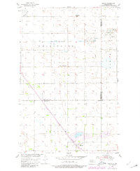
1954 Map of Barton
USGS Topo · Published 1980About this map
Barton sits at the southern end of this survey, serving as a focal point for the surrounding prairie landscape at the junction of the Burlington Northern railroad. The map reflects a rural educational system in transition, featuring the Pleasant Valley Sch alongside the already-labeled School No 2 (Abandoned) to the north. These small school sites, often the only landmarks in their respective sections, anchor the social history of the townships. The terrain is defined by the winding paths of Ox Creek and Willow Creek, which meander through the townships of Wellington and South Valley. This 1954 documentation, updated in 1980, captures the persistent grid of section lines and gravel roads that organized North Dakota's agricultural heartland during the mid-to-late 20th century.
Find a feature on this map
12 named features on this map. Tap any name to fly to it.
Don’t see what you’re looking for? This feature index may not catch every label — zoom into the map to look around manually.
Map Details
Editions of this 1954 Barton Map
2 editions found
Other maps of this area

1954 · Towner NE
USGS Topo · 1:24,000

1954 · Overly SE
USGS Topo · 1:24,000

1954 · Omemee
USGS Topo · 1:24,000

1954 · Barton
USGS Topo · 1:24,000

1954 · Round Lake
USGS Topo · 1:24,000

1954 · Leverich
USGS Topo · 1:24,000

1954 · Willow City
USGS Topo · 1:24,000

1954 · Minot
USGS Topo · 1:250,000

1955 · Fonda
USGS Topo · 1:24,000

1955 · Overly
USGS Topo · 1:24,000