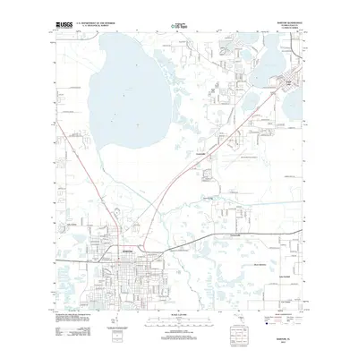
2012 Map of Bartow
USGS Topo · Published 2012About this map
Bartow stands as a primary hub in this central Florida landscape, positioned between the extensive waters of Lake Hancock and the winding course of the Peace River. The map reveals a high concentration of local history markers, particularly the cluster of burial grounds including Evergreen Cem, Palm Cem, Oak Hill Cem, and Wildwood Cem near the town center. To the northeast, the community of Eagle Lake borders its namesake water body, while the surrounding area is dotted with smaller settlements like Gordonville, Connersville, and the historically named Roux Quarters. The terrain is defined by its complex hydrology, where Saddle Cr and Phyllis Br feed into a network of lakes including Spirit Lake, Dinner Lake, and Lake Garfield. Modern infrastructure is represented by the Bartow Municipal Airport and several major crossings, such as the Spessard L Holland Bridge, which facilitate travel through this water-rich region of Polk County.
Find a feature on this map
195 named features on this map. Tap any name to fly to it.
Don’t see what you’re looking for? This feature index may not catch every label — zoom into the map to look around manually.
Map Details
Editions of this 2012 Bartow Map
This is the sole edition of this map. No revisions or reprints were ever made.
Other maps of this area

1944 · Lakeland
USGS Topo · 1:31,680

1944 · Auburndale
USGS Topo · 1:31,680

1949 · Mulberry
USGS Topo · 1:24,000

1949 · Bartow
USGS Topo · 1:24,000

1949 · Bradley Junction
USGS Topo · 1:24,000

1950 · Mulberry
USGS Topo · 1:24,000

1950 · Bartow
USGS Topo · 1:24,000

1950 · Bradley Junction
USGS Topo · 1:24,000

1952 · Homeland
USGS Topo · 1:24,000

1955 · Eloise
USGS Topo · 1:24,000