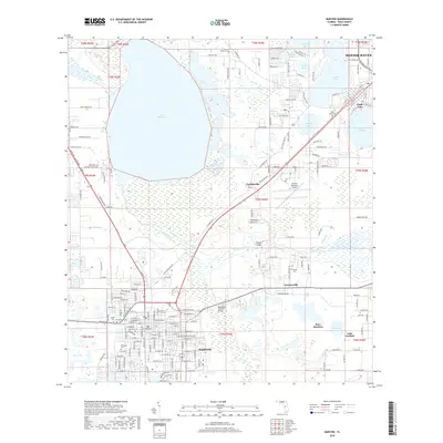
2018 Map of Bartow
USGS Topo · Published 2018About this map
Bartow sits as the focal point of this Central Florida survey, where the street grid of the city meets an expansive network of wetlands and citrus-region lakes. The landscape is defined by the headwaters of the Peace River, which flows south from the confluence of Saddle Creek and Peace Creek. Large water bodies like Lake Hancock and Spirit Lake dominate the northern half, while smaller basins such as Lake Ruth and Hack Lake are integrated into the urban fabric. This era shows a community shaped by its cemeteries, with numerous historic sites including Oak Hill Cem, Wildwood Cem, and Palm Cem clustered near the town center. The integration of infrastructure is evident at the Bartow Municipal Airport, situated between the residential areas of Gordonville and Connersville, illustrating the mid-20th-century expansion of local aviation alongside traditional agricultural and residential corridors.
Find a feature on this map
90 named features on this map. Tap any name to fly to it.
Don’t see what you’re looking for? This feature index may not catch every label — zoom into the map to look around manually.
Map Details
Editions of this 2018 Bartow Map
This is the sole edition of this map. No revisions or reprints were ever made.
Other maps of this area

1944 · Lakeland
USGS Topo · 1:31,680

1944 · Auburndale
USGS Topo · 1:31,680

1949 · Mulberry
USGS Topo · 1:24,000

1949 · Bartow
USGS Topo · 1:24,000

1949 · Bradley Junction
USGS Topo · 1:24,000

1950 · Mulberry
USGS Topo · 1:24,000

1950 · Bartow
USGS Topo · 1:24,000

1950 · Bradley Junction
USGS Topo · 1:24,000

1952 · Homeland
USGS Topo · 1:24,000

1955 · Eloise
USGS Topo · 1:24,000