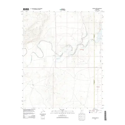
2013 Map of Bascom Camp
USGS Topo · Published 2013About this map
Canadian River winds through the northern portion of this landscape, carving a deep course through the mesas of eastern New Mexico. The confluence where Pajarito Creek meets the river is the central geographic anchor for this 2013 survey, which documents a region defined by its ranching history and modern water management. Along the eastern edge of the map, the waters of the Ute Reservoir reach into the canyons, marking the boundary between San Miguel County and Quay County. Small landmarks such as Bascom Camp and Bascom Pens indicate the ongoing agricultural use of the land, while the small settlement of Curtis sits near the eastern section lines. The map captures the intersection of natural watercourses like Carros Cr with the rigid township and range lines of t13n r31e and t12n r31e, providing a precise look at the rural road network including Quay Road 72 and Quay Road AJ.
Find a feature on this map
14 named features on this map. Tap any name to fly to it.
Don’t see what you’re looking for? This feature index may not catch every label — zoom into the map to look around manually.
Map Details
Editions of this 2013 Bascom Camp Map
This is the sole edition of this map. No revisions or reprints were ever made.
Other maps of this area

1930 · Tucumcari
USGS Topo · 1:125,000

1954 · Tucumcari
USGS Topo · 1:250,000

1958 · Tucumcari
USGS Topo · 1:250,000

1967 · Trinchera Creek
USGS Topo · 1:24,000

1967 · Liberty Mesa
USGS Topo · 1:24,000

1967 · Tucumcari
USGS Topo · 1:24,000

1968 · Bascom Camp
USGS Topo · 1:24,000

1968 · Hampton Ranch
USGS Topo · 1:24,000

1968 · Hudson
USGS Topo · 1:24,000

1968 · Lesbia
USGS Topo · 1:24,000