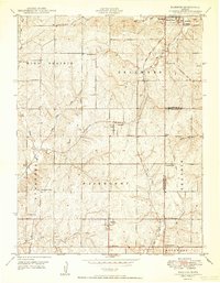
1950 Map of Basehor
USGS Topo · Published 1950About this map
Lansing and the grounds of the Kansas State Penitentiary dominate the northeastern corner of this mid-century landscape, where the rolling agricultural uplands of Leavenworth and Wyandotte Counties meet. This era shows a community structured around rural education and faith, with numerous neighborhood institutions like Spring Hill School, Little Stranger Church, and Timber Ridge School scattered across townships like Fairmount and High Prairie.
Find a feature on this map
34 named features on this map. Tap any name to fly to it.
Don’t see what you’re looking for? This feature index may not catch every label — zoom into the map to look around manually.
Map Details
Editions of this 1950 Basehor Map
3 editions found
Other maps of this area

1886 · Oskaloosa
USGS Topo · 1:125,000

1888 · Oskaloosa
USGS Topo · 1:125,000

1890 · Kansas City
USGS Topo · 1:125,000

1894 · Kansas City
USGS Topo · 1:125,000

1894 · Oskaloosa
USGS Topo · 1:125,000

1910 · Leavenworth
USGS Topo · 1:62,500

1934 · Bonner Springs
USGS Topo · 1:48,000

1934 · Edwardsville
USGS Topo · 1:24,000

1934 · Wolcott
USGS Topo · 1:24,000

1940 · Bonner Springs
USGS Topo · 1:62,500