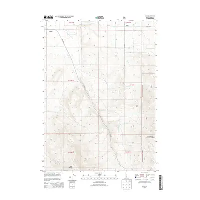
2013 Map of Basin
USGS Topo · Published 2013About this map
The agricultural and high-desert terrain of Cassia County is defined here by the small community of Basin and the eastern edge of Oakley. The landscape transitions from the flat valley floor where Basin Rd connects local farms to the rising elevations of the Sawtooth National Forest. Water management is central to the area's history, evidenced by the Summit Cr Ditch and the natural flows of Mill Cr and Summit Cr. Genealogists will find the Basin Cem located north of Warm Spring, while the southern portion of the map is dominated by the prominent mass of Middle Mountain. The presence of both Hot Spring and Warm Spring indicates the geothermal character of the region, tucked between the settlements and the distinct geological formation of Camel Rock.
Find a feature on this map
32 named features on this map. Tap any name to fly to it.
Don’t see what you’re looking for? This feature index may not catch every label — zoom into the map to look around manually.
Map Details
Editions of this 2013 Basin Map
This is the sole edition of this map. No revisions or reprints were ever made.
Other maps of this area

1954 · Pocatello
USGS Topo · 1:250,000

1958 · Pocatello
USGS Topo · 1:250,000

1968 · Almo
USGS Topo · 1:24,000

1968 · Cache Peak
USGS Topo · 1:24,000

1968 · Basin
USGS Topo · 1:24,000
1968 · Blue Hill
USGS Topo · 1:24,000

1968 · Marion SE
USGS Topo · 1:24,000
1968 · Oakley
USGS Topo · 1:24,000

1968 · Mount Harrison
USGS Topo · 1:24,000

1968 · Lyman Pass
USGS Topo · 1:24,000