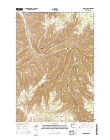
2014 Map of Bassey Creek
USGS Topo · Published 2014About this map
Storm Mountain dominates the western topography of this high-elevation landscape in Umatilla County, where the Blue Mountains geography is defined by a dense network of canyons and springs. Drainage patterns follow steep-walled cuts like Lawler Canyon, Denson Canyon, and Gibson Canyon, feeding into the larger course of McKay Cr. This 2014 survey captures a terrain largely utilized for forestry and watershed management, with a road network consisting primarily of service and access routes like Shaw-Lower McKay Rd and Rocky Ridge Rd. High ridges such as Baldy Ridge and Johnson Ridge frame the eastern portion of the quadrangle. The naming of localized water sources like Watkins Spring, Elder Spring, and Mathis Spring points to a landscape where specific water points were critical for land management and early homesteading efforts in these high canyons.
Find a feature on this map
39 named features on this map. Tap any name to fly to it.
Don’t see what you’re looking for? This feature index may not catch every label — zoom into the map to look around manually.
Map Details
Editions of this 2014 Bassey Creek Map
This is the sole edition of this map. No revisions or reprints were ever made.
Other maps of this area

1935 · Pendleton
USGS Topo · 1:125,000

1953 · Pendleton
USGS Topo · 1:250,000

1956 · Pendleton
USGS Topo · 1:250,000

1963 · Meacham Lake
USGS Topo · 1:24,000

1964 · Mc Intyre Creek
USGS Topo · 1:24,000

1964 · Meacham
USGS Topo · 1:24,000

1966 · Cabbage Hill
USGS Topo · 1:24,000

1966 · Table Rock
USGS Topo · 1:24,000
1967 · Bassey Creek
USGS Topo · 1:24,000

1967 · Bally Mountain
USGS Topo · 1:24,000