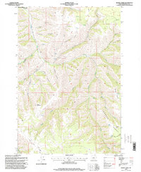
1996 Map of Bassey Creek
USGS Topo · Published 1998About this map
Storm Mountain and the high ridges of the Blue Mountains dominate this part of Umatilla County, where deep incisions like Mc Kay Canyon and Lawler Canyon define the drainage patterns of the upper Mc Kay Creek watershed. The landscape is a network of named springs and seasonal draws, such as Green Spring and Marlin Spring, which sustained early forest management and grazing operations. Evidence of land management and infrastructure is seen in the placement of Johnson Tower and Buckhorn Camp along the prominent Johnson Ridge. The northwestern corner of the map reaches the Umatilla Indian Reservation Bdy, marking a significant political and cultural boundary. Transport in the mid-1990s relied on a network of 4WD trails and forest roads that followed the contours of Baldy Ridge and Rocky Ridge, providing access to isolated points like Wood Lake.
Find a feature on this map
34 named features on this map. Tap any name to fly to it.
Don’t see what you’re looking for? This feature index may not catch every label — zoom into the map to look around manually.
Map Details
Editions of this 1996 Bassey Creek Map
This is the sole edition of this map. No revisions or reprints were ever made.
Other maps of this area

1935 · Pendleton
USGS Topo · 1:125,000

1953 · Pendleton
USGS Topo · 1:250,000

1956 · Pendleton
USGS Topo · 1:250,000

1963 · Meacham Lake
USGS Topo · 1:24,000

1964 · Mc Intyre Creek
USGS Topo · 1:24,000

1964 · Meacham
USGS Topo · 1:24,000

1966 · Cabbage Hill
USGS Topo · 1:24,000

1966 · Table Rock
USGS Topo · 1:24,000
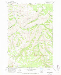
1967 · Bassey Creek
USGS Topo · 1:24,000

1967 · Bally Mountain
USGS Topo · 1:24,000