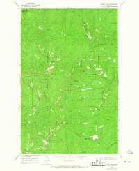
1964 Map of Bassoo Peak
USGS Topo · Published 1967About this map
The Flathead Indian Reservation Boundary divides this mountainous landscape, marking a significant intersection of jurisdictional and forest lands in the mid-1960s. Surveyed by the U.S. Geological Survey, the area is defined by the high elevations of Bassoo Peak, Thompson Peak, and Snowstorm Mountain, which straddle the divide between the Flathead National Forest and the Lolo National Forest. The map detail reveals a remote wilderness terrain navigated primarily by a network of Pack Trails rather than developed roads.
Find a feature on this map
21 named features on this map. Tap any name to fly to it.
Don’t see what you’re looking for? This feature index may not catch every label — zoom into the map to look around manually.
Map Details
Editions of this 1964 Bassoo Peak Map
This is the sole edition of this map. No revisions or reprints were ever made.
Other maps of this area

1956 · Wallace
USGS Topo · 1:250,000

1960 · Wallace
USGS Topo · 1:250,000

1964 · Mill Pocket Creek
USGS Topo · 1:24,000

1964 · Coney Peak
USGS Topo · 1:24,000

1964 · Hubbart Reservoir
USGS Topo · 1:24,000
1964 · Cook Mountain
USGS Topo · 1:24,000
1964 · Shroder Creek
USGS Topo · 1:24,000

1964 · Murr Peak
USGS Topo · 1:24,000

1964 · Lonepine
USGS Topo · 1:24,000
1964 · Loneman Creek
USGS Topo · 1:24,000