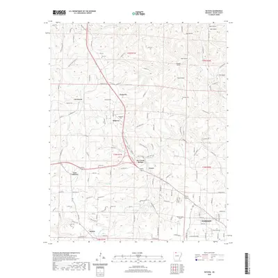
2020 Map of Batavia
USGS Topo · Published 2020About this map
The rolling hills of Boone County center on the intersection of modern transportation and quiet homesteads, where Bear Creek Springs and Francis sit at the junction of local routes. The landscape is defined by its drainages, including the Rolands Fork and Dry Fork, which carve through the Ozark topography alongside deep-set terrain features like Wolf Hollow and Sweet Hollow. This 2020 record of the area highlights the persistent rural character of the region, where family and community landmarks such as Gass Cem and Loback Cem remain as physical anchors in the countryside. Toward the southeast, the urban footprint of Harrison begins to emerge, anchored by the Boone County Airport. The settlement patterns here follow the ridges and creek beds, with small communities like Batavia and Prosperity connected by an intricate network of local roads like Burlington Loop and Saddle Back Rd.
Find a feature on this map
129 named features on this map. Tap any name to fly to it.
Don’t see what you’re looking for? This feature index may not catch every label — zoom into the map to look around manually.
Map Details
Editions of this 2020 Batavia Map
This is the sole edition of this map. No revisions or reprints were ever made.
Other maps of this area

1904 · Harrison
USGS Topo · 1:125,000

1905 · Harrison
USGS Topo · 1:125,000

1945 · Harrison
USGS Topo · 1:250,000

1949 · Harrison
USGS Topo · 1:250,000

1954 · Harrison
USGS Topo · 1:250,000

1958 · Harrison
USGS Topo · 1:250,000

1964 · Harrison
USGS Topo · 1:250,000
1966 · Omaha NE
USGS Topo · 1:24,000
1967 · Gaither
USGS Topo · 1:24,000
1967 · Bergman
USGS Topo · 1:24,000