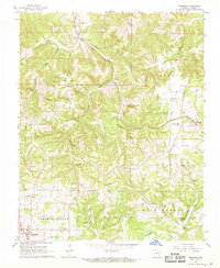
1967 Map of Bergman
USGS Topo · Published 1968About this map
Missouri Pacific rail lines cut through the heart of this Boone County landscape, connecting the town of Bergman and the rural community of Myrtle. The map reveals a transition from the developing northern fringes of Harrison to the dissected plateaus of the Ozarks. In the south, the Drive-in Theater and Oak Grove Sch indicate mid-century community expansion, while the interior is dotted with legacy features such as Hopewell Ch and Wesleyan Ch. The terrain is defined by complex drainage systems including Bear Creek, Cheatham Creek, and Crooked Creek, which have shaped the settlement patterns of locations like Wooden Hills. Local history is preserved through numerous family and community burial grounds, such as York Cem and Bethany Cem, nestled among the ridges of Lee and Elixir townships.
Find a feature on this map
47 named features on this map. Tap any name to fly to it.
Don’t see what you’re looking for? This feature index may not catch every label — zoom into the map to look around manually.
Map Details
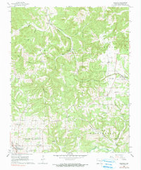
Editions of this 1967 Bergman Map
2 editions found
Other maps of this area

1893 · Yellville
USGS Topo · 1:125,000

1903 · Yellville
USGS Topo · 1:125,000

1904 · Harrison
USGS Topo · 1:125,000

1905 · Harrison
USGS Topo · 1:125,000

1905 · Yellville
USGS Topo · 1:125,000

1929 · Yellville
USGS Topo · 1:125,000

1945 · Harrison
USGS Topo · 1:250,000

1949 · Harrison
USGS Topo · 1:250,000

1954 · Harrison
USGS Topo · 1:250,000

1958 · Harrison
USGS Topo · 1:250,000