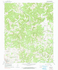
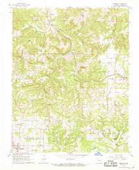
1967 Map of Bergman
USGS Topo · Published 1990About this map
The Missouri Pacific railroad corridor anchors the eastern edge of this Boone County landscape, connecting the small community of Bergman and the rural crossroads of Oregon Flat. The terrain is defined by the winding paths of Cheatham Creek and Bear Creek, which carve through a network of hollows and ridges. Toward the southwest, the outskirts of Harrison emerge, featuring landmarks like the Maplewood Cem and a Drive-in Theater near the Oak Grove Sch.
Find a feature on this map
37 named features on this map. Tap any name to fly to it.
Don’t see what you’re looking for? This feature index may not catch every label — zoom into the map to look around manually.
Map Details
Editions of this 1967 Bergman Map
2 editions found
Other maps of this area

1893 · Yellville
USGS Topo · 1:125,000

1903 · Yellville
USGS Topo · 1:125,000

1904 · Harrison
USGS Topo · 1:125,000

1905 · Harrison
USGS Topo · 1:125,000

1905 · Yellville
USGS Topo · 1:125,000

1929 · Yellville
USGS Topo · 1:125,000

1945 · Harrison
USGS Topo · 1:250,000

1949 · Harrison
USGS Topo · 1:250,000

1954 · Harrison
USGS Topo · 1:250,000

1958 · Harrison
USGS Topo · 1:250,000