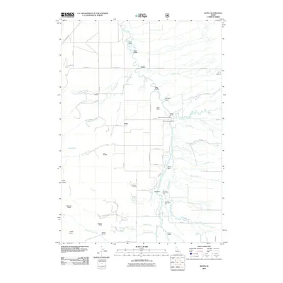
2011 Map of Bates
USGS Topo · Published 2011About this map
The Teton Basin dominates this portion of Teton County, Idaho, where the Teton River meanders through a landscape defined by its complex hydrology. The settlement of Bates serves as a central point in a network of rural roads such as W Bates Rd and S Bates Rd, connecting local families to historic sites like the Bates Cemetery and Cedron Cemetery. The map documents a significant water management system, featuring the Tonks Canal and various river access points, including the Nickerson Bridge Access Area and Fox Creek West Access Area. To the west, the terrain rises toward Patterson Ridge and Horse Heaven, while the drainage of Mahogany Creek and the multiple forks of the Teton River—specifically Three Forks and Twin Forks—illustrate the natural irrigation of the valley floor.
Find a feature on this map
67 named features on this map. Tap any name to fly to it.
Don’t see what you’re looking for? This feature index may not catch every label — zoom into the map to look around manually.
Map Details
Editions of this 2011 Bates Map
This is the sole edition of this map. No revisions or reprints were ever made.
Other maps of this area

1943 · Driggs
USGS Topo · 1:62,500

1943 · Garns Mtn
USGS Topo · 1:62,500

1946 · Driggs
USGS Topo · 1:62,500

1946 · Garns Mtn
USGS Topo · 1:62,500

1955 · Driggs
USGS Topo · 1:250,000

1958 · Driggs
USGS Topo · 1:250,000

1962 · Driggs
USGS Topo · 1:250,000

1965 · Packsaddle Lake
USGS Topo · 1:24,000

1965 · Clawson
USGS Topo · 1:24,000
1965 · Tetonia
USGS Topo · 1:24,000