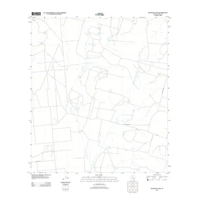
2013 Map of Batesville SW
USGS Topo · Published 2013About this map
Water management in the arid Brush Country of Zavala County is the dominant theme of this landscape, where a sophisticated network of tanks and creek branches supports ranching operations. The terrain is drained by the ephemeral Tortuga Cr and its tributaries, including E Br Tortuga Cr, leading toward the drainage of Arroyo Negro. The human presence is marked by named catchment features that likely correspond to historic land holdings, such as Silver Lake Tank, Lost Waterhole Tank, and Badger Hole Tank. This 2013 survey illustrates the continued reliance on these scattered water sources, linked by a web of local tracks and state-maintained routes like Ranch Road 1025 and FM-1867, which traverse the open range between larger South Texas settlements.
Find a feature on this map
27 named features on this map. Tap any name to fly to it.
Don’t see what you’re looking for? This feature index may not catch every label — zoom into the map to look around manually.
Map Details
Editions of this 2013 Batesville SW Map
This is the sole edition of this map. No revisions or reprints were ever made.
Other maps of this area

1939 · Carrizo Springs
USGS Topo · 1:62,500

1939 · Big Wells
USGS Topo · 1:62,500

1939 · La Pryor
USGS Topo · 1:62,500

1953 · Crystal City
USGS Topo · 1:250,000

1955 · Crystal City
USGS Topo · 1:250,000

1957 · Batesville
USGS Topo · 1:62,500

1961 · Crystal City
USGS Topo · 1:250,000

1968 · Crystal City
USGS Topo · 1:250,000
1972 · Batesville
USGS Topo · 1:24,000
1972 · Batesville SW
USGS Topo · 1:24,000