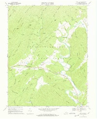
1968 Map of Bath Alum
USGS Topo · Published 1969About this map
The Cowpasture River carves a winding path through the heart of this Appalachian landscape, defining the topography between the George Washington National Forest and the heights of Warm Springs Mountain. In the late 1960s, the small communities of Bath Alum and McClung served as the primary settlement points, clustered near the junction of Thompson Creek and the river. The map reveals a high concentration of local heritage sites, including the Woodland Ch Cem and Westminster Chapel Cem, alongside the Windy Cove Ch at the southern bend of the river.
Find a feature on this map
62 named features on this map. Tap any name to fly to it.
Don’t see what you’re looking for? This feature index may not catch every label — zoom into the map to look around manually.
Map Details
Editions of this 1968 Bath Alum Map
Other maps of this area

1894 · Natural Bridge
USGS Topo · 1:125,000

1901 · Monterey
USGS Topo · 1:125,000

1923 · Warm Springs
USGS Topo · 1:48,000

1926 · Warm Springs
USGS Topo · 1:62,500

1930 · Warm Springs Run
USGS Topo · 1:24,000

1931 · Healing Springs
USGS Topo · 1:24,000

1933 · Warm Springs Run
USGS Topo · 1:31,680

1933 · Healing Springs
USGS Topo · 1:31,680

1945 · Clifton Forge
USGS Topo · 1:62,500

1946 · Millboro
USGS Topo · 1:62,500