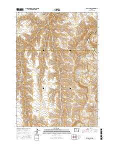
2017 Map of Bath Canyon
USGS Topo · Published 2017About this map
John Day River flows through the northeastern corner of this high-desert landscape, marking the tri-county intersection of Wasco, Sherman, and Gilliam Counties. This 2017 survey reveals a terrain defined by deep drainages and ridges, where named features often reflect historical land use and early ranching. High points like Sugarloaf and North Pole Ridge overlook a network of canyons including Bath Canyon, McGilvery Canyon, and Whitten Canyon. The distribution of water sources, such as Rattlesnake Spring, Heany Spring, and Duncan Spring, indicates the critical nature of water management in these upland areas. Notable topographic landmarks such as Butte Creek Pass and Little Pine Hollow Ridge provide insight into the natural corridors through which early movement occurred across this portion of north-central Oregon.
Find a feature on this map
33 named features on this map. Tap any name to fly to it.
Don’t see what you’re looking for? This feature index may not catch every label — zoom into the map to look around manually.
Map Details
Editions of this 2017 Bath Canyon Map
This is the sole edition of this map. No revisions or reprints were ever made.
Other maps of this area

1916 · Condon
USGS Topo · 1:125,000

1926 · Mitchell
USGS Topo · 1:125,000

1953 · The Dalles
USGS Topo · 1:250,000

1955 · Bend
USGS Topo · 1:250,000

1956 · The Dalles
USGS Topo · 1:250,000

1957 · Bend
USGS Topo · 1:250,000

1957 · The Dalles
USGS Topo · 1:250,000

1958 · Bend
USGS Topo · 1:250,000

1966 · Antelope
USGS Topo · 1:62,500

1966 · Clarno
USGS Topo · 1:62,500