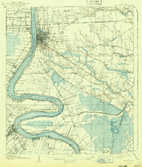
1908 Map of Baton Rouge
USGS Topo · Published 1943About this map
Baton Rouge serves as the focal point of this Mississippi River survey, depicting the city during a period of intense river commerce and early 20th-century rail expansion. The river itself dominates the landscape with dramatic bends at Duncan Point, Manchac Point, and Plaquemine Point. Numerous river landings, such as Evergreen Ldg and Lucky Plantation Ldg, line the banks, signaling the agricultural and shipping reliance on the waterway.
Find a feature on this map
87 named features on this map. Tap any name to fly to it.
Don’t see what you’re looking for? This feature index may not catch every label — zoom into the map to look around manually.
Map Details
Editions of this 1908 Baton Rouge Map
2 editions found
Other maps of this area

1892 · Donaldsonville
USGS Topo · 1:62,500

1906 · Bayou Sara
USGS Topo · 1:125,000

1908 · Baton Rouge
USGS Topo · 1:62,500

1934 · Denham Springs
USGS Topo · 1:62,500

1935 · Gonzales
USGS Topo · 1:31,680

1935 · Chicot Lake
USGS Topo · 1:62,500

1936 · White Castle
USGS Topo · 1:62,500

1939 · Zachary
USGS Topo · 1:62,500

1939 · Denham Springs
USGS Topo · 1:62,500

1939 · Baton Rouge
USGS Topo · 1:62,500