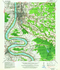
1939 Map of Baton Rouge
USGS Topo · Published 1962About this map
The Mississippi River dominates this pre-war landscape, carving massive loops through West Baton Rouge and East Baton Rouge parishes. Industrial and agricultural life clusters along the water at locations like the Gaya Plantation & Refinery and various landings such as Cinclare Log and Hope Estate Ldg. In Baton Rouge, the survey shows the expanding footprint of University Gardens and College Hills near the riverfront. Further inland, the map captures a network of rural community centers defined by combined institutions like the Rose Hill Ch Sch & Cem and the Bible Students Sh & Cem. The rail-dependent economy is visible through the Texas & Pacific RR and Illinois Central RR lines, which connect small settlements like Iberville and Burtville to the capital city.
Find a feature on this map
125 named features on this map. Tap any name to fly to it.
Don’t see what you’re looking for? This feature index may not catch every label — zoom into the map to look around manually.
Map Details
Editions of this 1939 Baton Rouge Map
4 editions found
Other maps of this area

1892 · Donaldsonville
USGS Topo · 1:62,500

1906 · Bayou Sara
USGS Topo · 1:125,000

1908 · Baton Rouge
USGS Topo · 1:62,500

1934 · Denham Springs
USGS Topo · 1:62,500

1935 · Gonzales
USGS Topo · 1:31,680

1935 · Chicot Lake
USGS Topo · 1:62,500

1936 · White Castle
USGS Topo · 1:62,500

1939 · Zachary
USGS Topo · 1:62,500

1939 · Denham Springs
USGS Topo · 1:62,500

1939 · Baton Rouge
USGS Topo · 1:62,500