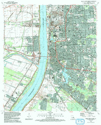
1992 Map of Baton Rouge West
USGS Topo · Published 1992About this map
The Mississippi River divides this landscape, separating the bustling capital of Baton Rouge from the industrial and agricultural lands of West Baton Rouge Parish. In the early 1990s, the east bank is defined by the expansive campus of Louisiana State University and A & M College, surrounding University Lake and City Park Lake. To the north, the State Capitol stands near the urban core of Istrouma and Delmont Place. Across the river, the Port Allen waterfront is dominated by the Port Allen Lock and the southern terminus of the Intercoastal Waterway. This western side retains visible ties to its agrarian past through sites like the Poplar Grove Plantation and Cinclare, while the presence of the Missouri Pacific RR and Illinois Central Gulf RR highlights the region's role as a major transportation and shipping hub.
Find a feature on this map
97 named features on this map. Tap any name to fly to it.
Don’t see what you’re looking for? This feature index may not catch every label — zoom into the map to look around manually.
Map Details
Editions of this 1992 Baton Rouge West Map
2 editions found
Other maps of this area

1906 · Bayou Sara
USGS Topo · 1:125,000

1908 · Baton Rouge
USGS Topo · 1:62,500

1939 · Zachary
USGS Topo · 1:62,500

1939 · Baton Rouge
USGS Topo · 1:62,500

1940 · Grosse Tete
USGS Topo · 1:62,500

1953 · Baton Rouge West
USGS Topo · 1:24,000

1953 · Plaquemine
USGS Topo · 1:24,000

1953 · Lobdell
USGS Topo · 1:24,000

1953 · Addis
USGS Topo · 1:24,000

1953 · St. Gabriel
USGS Topo · 1:24,000