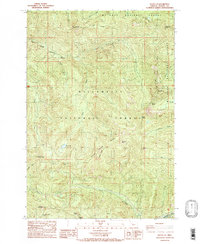
1985 Map of Battle Ax
USGS Topo · Published 1985About this map
Mt Hood National Forest and Willamette National Forest converge in this high-altitude landscape dominated by steep ridgelines and the headwaters of several major drainages. The Little North Santiam River carves through the western reach, while the Breitenbush River flows along the southern edge, fed by a network of steep-descending creeks including Battle Creek, Opal Creek, and French Creek. The topography is punctuated by distinctive geological formations such as Dog Tooth Rock, the Phantom Natural Bridge, and the prominent peak of Battle Ax.
Find a feature on this map
36 named features on this map. Tap any name to fly to it.
Don’t see what you’re looking for? This feature index may not catch every label — zoom into the map to look around manually.
Map Details
Editions of this 1985 Battle Ax Map
This is the sole edition of this map. No revisions or reprints were ever made.
Other maps of this area

1929 · Mill City
USGS Topo · 1:125,000

1953 · Salem
USGS Topo · 1:250,000

1954 · Salem
USGS Topo · 1:250,000

1955 · Mill City
USGS Topo · 1:62,500

1956 · Quartzville
USGS Topo · 1:62,500

1956 · Battle Ax
USGS Topo · 1:62,500

1956 · Detroit
USGS Topo · 1:62,500

1960 · Salem
USGS Topo · 1:250,000

1962 · Salem
USGS Topo · 1:250,000

1963 · Salem
USGS Topo · 1:250,000