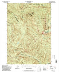
1994 Map of Battle Ax
USGS Topo · Published 1998About this map
Bull of the Woods Wilderness dominates this mid-1990s landscape, where complex mountain ridges and high-altitude lakes define the boundary between the Mount Hood National Forest and Willamette National Forest. The map details a primitive recreational network, highlighting the Whetstone Trail and Twin Lake Trail as they navigate peaks like Silver King Mountain and Sardine Mountain. A notable geological landmark, Phantom Natural Bridge, stands near the western edge above French Creek. The convergence of Humbug Creek, Beachie Creek, and the Breitenbush River suggests a watershed that remained largely untouched by major development during this era, focused instead on timber management and wilderness preservation. Hikers and researchers can trace the paths to remote waters such as Silver King Lake, Opal Lake, and Giebeler Lake, which are tucked deep within the high-relief terrain.
Find a feature on this map
32 named features on this map. Tap any name to fly to it.
Don’t see what you’re looking for? This feature index may not catch every label — zoom into the map to look around manually.
Map Details
Editions of this 1994 Battle Ax Map
This is the sole edition of this map. No revisions or reprints were ever made.
Other maps of this area

1929 · Mill City
USGS Topo · 1:125,000

1953 · Salem
USGS Topo · 1:250,000

1954 · Salem
USGS Topo · 1:250,000

1955 · Mill City
USGS Topo · 1:62,500

1956 · Quartzville
USGS Topo · 1:62,500

1956 · Battle Ax
USGS Topo · 1:62,500

1956 · Detroit
USGS Topo · 1:62,500

1960 · Salem
USGS Topo · 1:250,000

1962 · Salem
USGS Topo · 1:250,000

1963 · Salem
USGS Topo · 1:250,000