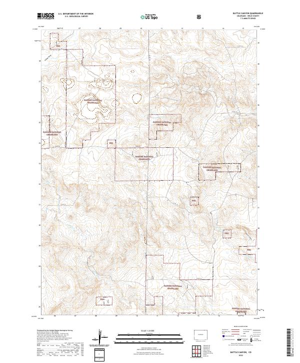
2022 Map of Battle Canyon
USGS Topo · Published 2022About this map
Pawnee National Grassland dominates this high plains landscape in Weld County, where a network of section lines and gravel routes like Tower Rd and Co RD 138 define the grazing territory. The terrain is marked by the distinct drainage of Twomile Creek and its tributary Twomile Cr, which carve through the arid topography alongside the namesake Battle Canyon. The presence of Uhl Reservoir and Cedar Cr in the eastern sections highlights the critical role of water management in this open range environment. Managed by the U.S. Forest Service, these lands represent the surviving prairie ecosystem of northern Colorado, maintaining the original survey grid established during the settlement of the American West. The map reveals the intricate boundaries of public and private land, often marked as PNG, within the sprawling federal holdings.
Find a feature on this map
18 named features on this map. Tap any name to fly to it.
Don’t see what you’re looking for? This feature index may not catch every label — zoom into the map to look around manually.
Map Details
Editions of this 2022 Battle Canyon Map
This is the sole edition of this map. No revisions or reprints were ever made.
Other maps of this area

1954 · Sterling
USGS Topo · 1:250,000

1954 · Scottsbluff
USGS Topo · 1:250,000

1958 · Scottsbluff
USGS Topo · 1:250,000

1958 · Sterling
USGS Topo · 1:250,000

1972 · Kimball SE
USGS Topo · 1:24,000

1972 · Kimball SW
USGS Topo · 1:24,000

1972 · Bushnell SE
USGS Topo · 1:24,000

1977 · Dipper Spring
USGS Topo · 1:24,000
1977 · Vim School
USGS Topo · 1:24,000
1977 · Gatehook Spring
USGS Topo · 1:24,000