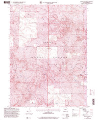
1997 Map of Battle Canyon
USGS Topo · Published 2000About this map
Pawnee National Grassland dominates this corner of Weld County, showing a landscape defined by ranching infrastructure and energy extraction in the late 20th century. Numerous markers for Oil Wells and Drill Holes are scattered across the high plains, particularly north of the prominent Battle Canyon terrain. Water management is central to the area's utility, as evidenced by several named windmills such as Rock Cave Windmill, Baker Windmill, and Two Mile Windmill. These features, along with the Uhl Reservoir, highlight the vital role of groundwater and storage in this arid environment. The map also captures specialized facilities like a Wildlife Enclosure and a central Communication Tower, illustrating the modern multi-use management of public lands. Natural drainages including Sidney Draw, Twomile Creek, and Cedar Creek provide the primary relief for the terrain, carving out the canyons and draws that break up the grassland plateau.
Find a feature on this map
16 named features on this map. Tap any name to fly to it.
Don’t see what you’re looking for? This feature index may not catch every label — zoom into the map to look around manually.
Map Details
Editions of this 1997 Battle Canyon Map
This is the sole edition of this map. No revisions or reprints were ever made.
Other maps of this area

1954 · Sterling
USGS Topo · 1:250,000

1954 · Scottsbluff
USGS Topo · 1:250,000

1958 · Scottsbluff
USGS Topo · 1:250,000

1958 · Sterling
USGS Topo · 1:250,000

1972 · Kimball SE
USGS Topo · 1:24,000

1972 · Kimball SW
USGS Topo · 1:24,000

1972 · Bushnell SE
USGS Topo · 1:24,000

1977 · Dipper Spring
USGS Topo · 1:24,000
1977 · Vim School
USGS Topo · 1:24,000
1977 · Gatehook Spring
USGS Topo · 1:24,000