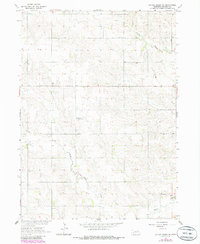
1963 Map of Battle Creek SE
USGS Topo · Published 1985About this map
Union Creek and its North Fork Union Creek wind through this rural section of Madison County, Nebraska, as it appeared in the early 1960s. The landscape reflects a traditional agrarian settlement pattern, defined by a grid of section roads and a high density of rural schoolhouses. Religious and social centers are anchored by landmarks like the St John Sch Green Garden Cem, which combines educational, spiritual, and commemorative functions in a single location. Further south, the Kalamazoo Cem serves as a lone marker of the area's genealogical history. The prevalence of numbered school districts, such as School No 15 and School No 66, suggests a decentralized community structure where small local schools were the cornerstone of childhood education before widespread consolidation took hold in the latter half of the century.
Find a feature on this map
11 named features on this map. Tap any name to fly to it.
Don’t see what you’re looking for? This feature index may not catch every label — zoom into the map to look around manually.
Map Details
Editions of this 1963 Battle Creek SE Map
2 editions found
Other maps of this area

1955 · Fremont
USGS Topo · 1:250,000

1957 · Fremont
USGS Topo · 1:250,000

1958 · Fremont
USGS Topo · 1:250,000

1963 · Madison
USGS Topo · 1:24,000

1963 · Battle Creek
USGS Topo · 1:24,000

1963 · Emerick
USGS Topo · 1:24,000
1963 · Enola
USGS Topo · 1:24,000

1963 · Battle Creek SE
USGS Topo · 1:24,000

1963 · Battle Creek SW
USGS Topo · 1:24,000
1966 · Lindsay
USGS Topo · 1:24,000