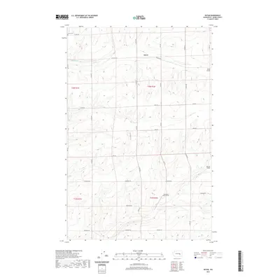
2020 Map of Batum
USGS Topo · Published 2020About this map
The settlement of Batum sits at the intersection of Griffith Rd and N Batum Rd, serving as a central point in this agricultural landscape of Adams County. The terrain is defined by the carved paths of Rocky Coulee and Farrier Coulee, which disrupt the otherwise orderly grid of section lines and gravel roads. This area preserves layers of local history, from the early spiritual life centered at Emmaus Cem in the northwest to the Cold War-era remains of a Titan Missile Silo located south of the main township. The presence of Tree Heart Ranch Airport and several isolated springs, such as Rock Spring, highlights the necessity of localized infrastructure in this expansive part of the Washington interior. The map documents a landscape where traditional farming roads like Schoessler Rd and Neergaard Rd connect remote ranching operations across the coulee-broken plains.
Find a feature on this map
32 named features on this map. Tap any name to fly to it.
Don’t see what you’re looking for? This feature index may not catch every label — zoom into the map to look around manually.
Map Details
Editions of this 2020 Batum Map
This is the sole edition of this map. No revisions or reprints were ever made.
Other maps of this area

1925 · Schrag
USGS Topo · 1:62,500

1953 · Ritzville
USGS Topo · 1:250,000

1959 · Ritzville
USGS Topo · 1:250,000

1965 · Ritzville
USGS Topo · 1:250,000

1967 · Reiman SW
USGS Topo · 1:24,000
1967 · Ruff
USGS Topo · 1:24,000

1967 · Batum
USGS Topo · 1:24,000
1967 · Weber
USGS Topo · 1:24,000

1967 · Reiman
USGS Topo · 1:24,000
1967 · Schrag
USGS Topo · 1:24,000