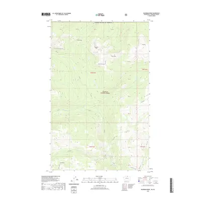
2020 Map of Bauerman Ridge
USGS Topo · Published 2020About this map
Bauerman Ridge and the high-elevation terrain of Okanogan National Forest dominate this 2020 landscape along the United States-Canada border. The map documents a watershed where Tungsten Cr and Cinch Cr feed into the Chewuch River, carving deep valleys through the mountain ranges. A major feature for modern navigation is the Pacific NW National Scenic Trail, which traverses the northern ridges, crossing near Scheelite Pass and the isolated Scheelite Lake. The presence of labels like Teapot Dome and Haig Mtn provides orientation for those following the high country. In the southern portion of the quadrangle, Vic Meadow and Coleman Ridge mark the transition toward the headwaters of Fire Creek, while the Cathedral Driveway provides a named access route into the rugged backcountry.
Find a feature on this map
42 named features on this map. Tap any name to fly to it.
Don’t see what you’re looking for? This feature index may not catch every label — zoom into the map to look around manually.
Map Details
Editions of this 2020 Bauerman Ridge Map
This is the sole edition of this map. No revisions or reprints were ever made.
Other maps of this area

1906 · Chopaka
USGS Topo · 1:125,000

1954 · Okanogan
USGS Topo · 1:250,000

1955 · Concrete
USGS Topo · 1:250,000

1956 · Horseshoe Basin
USGS Topo · 1:62,500

1958 · Concrete
USGS Topo · 1:250,000

1958 · Okanogan
USGS Topo · 1:250,000

1962 · Concrete
USGS Topo · 1:250,000

1969 · Mt. Barney
USGS Topo · 1:24,000

1969 · Remmel Mtn.
USGS Topo · 1:24,000
1969 · Coleman Peak
USGS Topo · 1:24,000