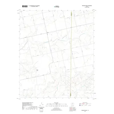
2019 Map of Baumann School
USGS Topo · Published 2019About this map
Baumann School sits as a central historic reference point in this West Texas landscape along the border of Mitchell and Nolan counties. The terrain is defined by the drainage networks of several seasonal waterways, most notably the S Fork Champion Cr and Hanks Hollow, which carve into the plains. The map reveals a rural structure dominated by a systematic grid of county roads and cattle ranching infrastructure, exemplified by the presence of Landers Ranch Airport. To the south and east, the topography becomes increasingly textured as it feeds into Big Silver Cr and Cottonwood Cr. This survey documents a quiet ranching district where local navigation relies on the intersection of secondary routes like FM 2319 and S FM 644, providing a clear view of land use and property boundaries in this portion of the Texas interior.
Find a feature on this map
32 named features on this map. Tap any name to fly to it.
Don’t see what you’re looking for? This feature index may not catch every label — zoom into the map to look around manually.
Map Details
Editions of this 2019 Baumann School Map
This is the sole edition of this map. No revisions or reprints were ever made.
Other maps of this area

1950 · Colorado City SE
USGS Topo · 1:24,000

1952 · Colorado City
USGS Topo · 1:24,000

1954 · Big Spring
USGS Topo · 1:250,000

1958 · Big Spring
USGS Topo · 1:250,000

1959 · Pecan Crossing
USGS Topo · 1:24,000

1959 · Dam Draw
USGS Topo · 1:24,000

1969 · Baumann School
USGS Topo · 1:24,000

1969 · Bench Mountain
USGS Topo · 1:24,000

1969 · Loraine
USGS Topo · 1:24,000
1969 · Dew Drop Creek
USGS Topo · 1:24,000