
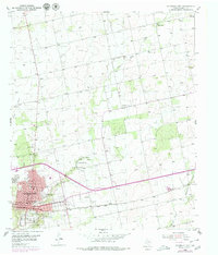
1952 Map of Colorado City
USGS Topo · Published 1953About this map
Colorado City serves as the focal point of this West Texas landscape, where the Texas and Pacific railroad bisects the town and drives the local economy. The residential grid is well-defined, supporting essential civic structures including the Courthouse, several local schools like Hutchinson Sch and Wallace Sch, and the municipal Waterworks. Beyond the city limits, the terrain is shaped by the winding course of Lone Wolf Creek and Champion Creek, which provide vital water sources in an area otherwise marked by intermittent drainage like Bone Hollow.
Find a feature on this map
31 named features on this map. Tap any name to fly to it.
Don’t see what you’re looking for? This feature index may not catch every label — zoom into the map to look around manually.
Map Details
Editions of this 1952 Colorado City Map
2 editions found
Other maps of this area

1950 · Cedar Bend
USGS Topo · 1:24,000

1950 · Lake Colorado City
USGS Topo · 1:24,000

1950 · Colorado City SE
USGS Topo · 1:24,000

1951 · Dunn
USGS Topo · 1:24,000

1952 · China Grove
USGS Topo · 1:24,000

1954 · Big Spring
USGS Topo · 1:250,000

1958 · Big Spring
USGS Topo · 1:250,000

1969 · Baumann School
USGS Topo · 1:24,000

1969 · Loraine
USGS Topo · 1:24,000
1969 · Inadale
USGS Topo · 1:24,000