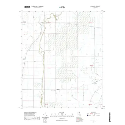
2020 Map of Baxter Bayou
USGS Topo · Published 2020About this map
Bayou Macon winds through this agricultural landscape on the border of West and East Carroll Parishes, its path punctuated by the Lanes Ferry Bridge and nearby Cockspur Lake. The terrain is defined by an intricate network of waterways, including Lyon Bayou, Baxter Bayou, and Russell Bayou, which suggest a long history of drainage management and flood control in these fertile lowlands. Along the western edge, the outskirts of Oak Grove appear, while the southeastern section features the Lone Star Cem and Cypress Brake. This survey reveals the persistent reliance on parish roads and ferry-named crossings to navigate the bayou-riven landscape. The presence of Tensas Ditch and Tensas Bayou further illustrates the complex hydrological engineering required to support the local farming economy in this corner of Louisiana.
Find a feature on this map
47 named features on this map. Tap any name to fly to it.
Don’t see what you’re looking for? This feature index may not catch every label — zoom into the map to look around manually.
Map Details
Editions of this 2020 Baxter Bayou Map
This is the sole edition of this map. No revisions or reprints were ever made.
Other maps of this area

1909 · Baxter Bayou
USGS Topo · 1:24,000

1909 · Lake Providence
USGS Topo · 1:24,000

1909 · Millikin
USGS Topo · 1:24,000

1909 · Ashton Bridge
USGS Topo · 1:24,000

1911 · Lake Providence
USGS Topo · 1:31,680

1911 · Baxter Bayou
USGS Topo · 1:24,000

1912 · Ashton Bridge
USGS Topo · 1:31,680

1914 · Baxter Bayou
USGS Topo · 1:31,680

1935 · Oak Grove
USGS Topo · 1:62,500

1939 · Alsatia
USGS Topo · 1:62,500