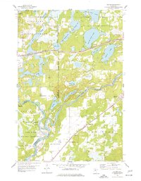
1954 Map of Baxter
USGS Topo · Published 1977About this map
Camp Ripley Military Reservation dominates the southern landscape of this mid-century survey where the Gull River converges with the Mississippi River. The region is defined by its complex hydrology, featuring numerous glacial basins such as White Sand Lake, Perch Lake, and the connected Upper Whipple Lake and Lower Whipple Lake. The Northern Pacific railroad cuts through the center of the quadrangle, facilitating the growth of Baxter and the settlement at Barrows. This period shows a transition in local infrastructure, with the Plumly Sch noted as abandoned while the Crow Wing Sch remains active near the southern border. The map also delineates established local landmarks like the Gull River Cem and the Community Ch, alongside extensive public lands within the Pillsbury State Forest and Sylvan State Forest.
Find a feature on this map
35 named features on this map. Tap any name to fly to it.
Don’t see what you’re looking for? This feature index may not catch every label — zoom into the map to look around manually.
Map Details
Editions of this 1954 Baxter Map
5 editions found
Other maps of this area

1915 · Brainerd
USGS Topo · 1:62,500

1916 · Pillager
USGS Topo · 1:62,500

1918 · Brainerd
USGS Topo · 1:62,500

1919 · Pillager
USGS Topo · 1:62,500

1948 · Belle Prairie
USGS Topo · 1:62,500

1948 · Lastrup
USGS Topo · 1:62,500

1950 · Lastrup
USGS Topo · 1:62,500

1950 · Belle Prairie
USGS Topo · 1:62,500

1953 · Brainerd
USGS Topo · 1:250,000

1954 · Baxter
USGS Topo · 1:24,000