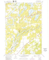
1954 Map of Baxter
USGS Topo · Published 1980About this map
The Mississippi River and Gull River converge in this detailed mapping of the lakes region south of Brainerd. The landscape is defined by the industrial presence of the Northern Pacific railroad corridor, which skirts the northern edge of the Baxter village boundary. Significant land use is devoted to the sprawling Camp Ripley Military Reservation and the adjacent Crow Wing State Park, preserving the riparian environment where the rivers meet. Local life is reflected in small landmarks like the Fish Hatchery and Community Ch. The terrain is dominated by glacial water bodies, including the twin basins of Upper Whipple Lake and Lower Whipple Lake, alongside the larger White Sand Lake. Genealogists may find value in the presence of the Gull River Cem and Oak Land Cem, while the hamlet of Barrows and the Crow Wing Sch mark the rural social hubs of the mid-century era.
Find a feature on this map
40 named features on this map. Tap any name to fly to it.
Don’t see what you’re looking for? This feature index may not catch every label — zoom into the map to look around manually.
Map Details
Editions of this 1954 Baxter Map
5 editions found
Other maps of this area

1915 · Brainerd
USGS Topo · 1:62,500

1916 · Pillager
USGS Topo · 1:62,500

1918 · Brainerd
USGS Topo · 1:62,500

1919 · Pillager
USGS Topo · 1:62,500

1948 · Belle Prairie
USGS Topo · 1:62,500

1948 · Lastrup
USGS Topo · 1:62,500

1950 · Lastrup
USGS Topo · 1:62,500

1950 · Belle Prairie
USGS Topo · 1:62,500

1953 · Brainerd
USGS Topo · 1:250,000

1954 · Baxter
USGS Topo · 1:24,000