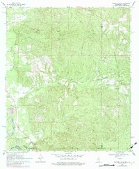
1969 Map of Baxterville SW
USGS Topo · Published 1982About this map
The Pearl River defines the southwestern boundary of this landscape, carving through the borderlands where Mississippi and Louisiana meet. During this period of the late 1960s, the region was characterized by a network of rural churches and family landmarks, including Sweet Home Ch, Rose Hill Ch, and New Hope Ch. The terrain is marked by significant elevations such as Stony Point Hill and Red Hill, while the industrial legacy of the area is visible in the Old Railroad Grade and numerous Gravel Pits.
Find a feature on this map
27 named features on this map. Tap any name to fly to it.
Don’t see what you’re looking for? This feature index may not catch every label — zoom into the map to look around manually.
Map Details
Editions of this 1969 Baxterville SW Map
4 editions found

Other maps of this area

1949 · Angie
USGS Topo · 1:31,680

1953 · Hattiesburg
USGS Topo · 1:250,000

1953 · Mobile
USGS Topo · 1:250,000

1957 · Mobile
USGS Topo · 1:250,000

1958 · Hattiesburg
USGS Topo · 1:250,000

1959 · Bogalusa
USGS Topo · 1:62,500

1959 · Poplarville
USGS Topo · 1:62,500

1960 · Mobile
USGS Topo · 1:250,000

1963 · Mobile
USGS Topo · 1:250,000

1965 · Mobile
USGS Topo · 1:250,000