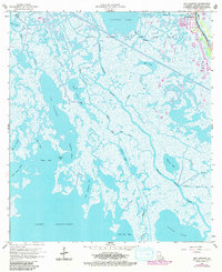
1964 Map of Bay Courant
USGS Topo · Published 1980About this map
Golden Meadow sits at the northeastern edge of this coastal Louisiana survey, where development is tightly concentrated along the western bank of Bayou Lafourche. This ribbon of infrastructure, marked by a Water Tank and the Serigny Cem, stands in sharp contrast to the sprawling wetlands and brackish waters to the west. The landscape is defined by the massive Golden Meadow Oil and Gas Field, which overlies a complex network of waterways including Catfish Lake and Bay Sevin.
Find a feature on this map
33 named features on this map. Tap any name to fly to it.
Don’t see what you’re looking for? This feature index may not catch every label — zoom into the map to look around manually.
Map Details
Editions of this 1964 Bay Courant Map
2 editions found
Other maps of this area

1892 · Cheniere Caminada
USGS Topo · 1:62,500

1892 · Creole
USGS Topo · 1:62,500

1894 · Timbalier
USGS Topo · 1:62,500

1894 · Lake Felicity
USGS Topo · 1:62,500

1935 · Viguerie Canal
USGS Topo · 1:31,680

1935 · Bay Courant
USGS Topo · 1:31,680

1935 · Golden Meadow
USGS Topo · 1:31,680

1935 · Pelican Pass
USGS Topo · 1:31,680

1935 · Mink Bayou
USGS Topo · 1:31,680

1935 · Leeville
USGS Topo · 1:31,680