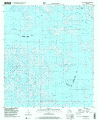
1998 Map of Bay Dosgris
USGS Topo · Published 2001About this map
Industrial energy infrastructure and coastal wetlands define this late 20th-century landscape on the boundary of Jefferson Parish and Lafourche Parish. The region is a complex network of marshes and water bodies including Little Lake, Bay Dosgris, and Hackberry Bay, heavily influenced by the extraction economy of the Manila Village Oil and Gas Field and the Bay De Chene Oil and Gas Field. Numerous offshore platforms are mapped throughout these waterways, connected by channels like Coffee Bayou and the prominent Barataria Waterway. Significant for local history, the Alombro Cem sits near the confluence of Snail Bayou and Bayou L'Ours. This survey documents a precarious environment where human industry, represented by extensive oil fields and a Radio Tower, operates within a fluid geography of indefinite boundaries and shifting bayous.
Find a feature on this map
43 named features on this map. Tap any name to fly to it.
Don’t see what you’re looking for? This feature index may not catch every label — zoom into the map to look around manually.
Map Details
Editions of this 1998 Bay Dosgris Map
This is the sole edition of this map. No revisions or reprints were ever made.
Other maps of this area

1891 · Pointe a La Hache
USGS Topo · 1:62,500

1892 · Barataria
USGS Topo · 1:62,500

1892 · Creole
USGS Topo · 1:62,500

1892 · Pointe a La Hache
USGS Topo · 1:62,500

1893 · Fort Livingston
USGS Topo · 1:62,500

1935 · Mink Bayou
USGS Topo · 1:31,680

1935 · Wilkinson Bay
USGS Topo · 1:31,680

1939 · Pointe a La Hache
USGS Topo · 1:62,500

1941 · Barataria
USGS Topo · 1:62,500

1944 · Barataria
USGS Topo · 1:62,500