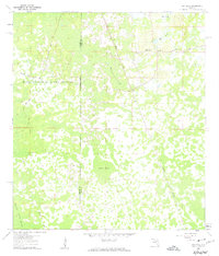
1960 Map of Bay Lake
USGS Topo · Published 1962About this map
The Withlacoochee State Forest dominates the western half of this Florida interior landscape, where the boundary between Sumter and Lake Counties cuts through a dense mosaic of wetlands and timberland. In the northeast, the small settlement of Bay Lake serves as a local anchor, centered around the Bay Lake Ch and the neighboring waters of Bay Lake and Mill Pond. The geography is defined by its drainage patterns, with the aptly named Bayroot Slough, Gator Hole, and the sprawling Devils Creek Swamp characterizing the low-lying terrain. Infrastructure is sparse and utilitarian, consisting of a network of forestry routes like North Grade Road and Center Grade Road, alongside a Jeep Trail. The Seaboard Air Line railroad provides the primary industrial artery, slicing diagonally through the eastern section of the forest and swamp.
Find a feature on this map
15 named features on this map. Tap any name to fly to it.
Don’t see what you’re looking for? This feature index may not catch every label — zoom into the map to look around manually.
Map Details
Editions of this 1960 Bay Lake Map
3 editions found
Other maps of this area

1955 · Plant City
USGS Topo · 1:250,000

1955 · Orlando
USGS Topo · 1:250,000

1957 · Orlando
USGS Topo · 1:250,000

1958 · Orlando
USGS Topo · 1:250,000

1958 · Plant City
USGS Topo · 1:250,000

1958 · Webster
USGS Topo · 1:24,000

1959 · Plant City
USGS Topo · 1:250,000

1959 · Lake Nellie
USGS Topo · 1:24,000

1959 · Poyner
USGS Topo · 1:24,000

1960 · Branchborough
USGS Topo · 1:24,000