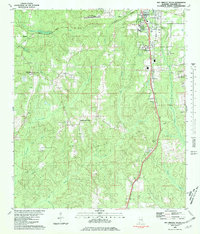
1980 Map of Bay Minette South
USGS Topo · Published 1981About this map
Bay Minette serves as the focal point for this southern Baldwin County landscape during the late 1970s and early 1980s. The area displays a transitional character between municipal development and the rural pine and creek lands of coastal Alabama. Significant educational and civic infrastructure is centered near the town, including Faulkner State Jr College and the Vocational Sch, while the Bay Minette Municipal Airport occupies the northern plateau.
Find a feature on this map
39 named features on this map. Tap any name to fly to it.
Don’t see what you’re looking for? This feature index may not catch every label — zoom into the map to look around manually.
Map Details
Editions of this 1980 Bay Minette South Map
2 editions found
Other maps of this area

1920 · Robertsdale
USGS Topo · 1:62,500

1921 · Fairhope
USGS Topo · 1:62,500

1941 · Blakeley
USGS Topo · 1:31,680

1941 · Bay Minette
USGS Topo · 1:62,500

1941 · Robertsdale
USGS Topo · 1:62,500

1941 · Fairhope
USGS Topo · 1:62,500

1942 · Hurricane
USGS Topo · 1:31,680
1942 · Blakeley
USGS Topo · 1:31,680

1942 · Dyas
USGS Topo · 1:62,500

1943 · Robertsdale
USGS Topo · 1:62,500