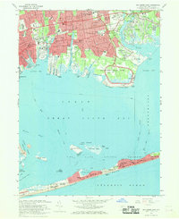
1967 Map of Bay Shore East
USGS Topo · Published 1969About this map
Fire Island National Seashore and the barrier beach communities define the southern extent of this 1960s survey, showing a distinct contrast between the dense suburban grid of the mainland and the isolated seasonal settlements of Kismet, Saltaire, and Ocean Beach. The mainland is characterized by established neighborhoods in Bay Shore, Islip, and East Islip, where the Long Island Railroad and Sunrise Highway facilitate movement across the South Shore. Landmarks such as the Fire Island Lighthouse and Adelphi Suffolk College anchor the local geography.
Find a feature on this map
86 named features on this map. Tap any name to fly to it.
Don’t see what you’re looking for? This feature index may not catch every label — zoom into the map to look around manually.
Map Details
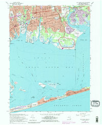
Editions of this 1967 Bay Shore East Map
2 editions found
Other maps of this area

1901 · Babylon
USGS Topo · 1:62,500

1901 · Northport
USGS Topo · 1:62,500

1902 · Setauket
USGS Topo · 1:62,500

1902 · Fire Island
USGS Topo · 1:62,500

1903 · Babylon
USGS Topo · 1:62,500

1903 · Northport
USGS Topo · 1:62,500

1903 · Fire Island
USGS Topo · 1:62,500

1904 · Setauket
USGS Topo · 1:62,500

1904 · Islip
USGS Topo · 1:125,000

1919 · Setauket
USGS Topo · 1:62,500