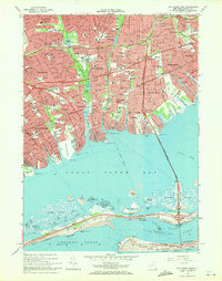
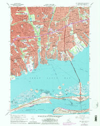
1969 Map of Bay Shore West
USGS Topo · Published 1971This historical map portrays the area of Bay Shore West in 1969, primarily covering Suffolk County. Featuring a scale of 1:24000, this map provides a highly detailed snapshot of the terrain, roads, buildings, counties, and historical landmarks in the Bay Shore West region at the time. Published in 1971, it is one of 3 known editions of this map due to revisions or reprints.
Find a feature on this map
106 named features on this map. Tap any name to fly to it.
Don’t see what you’re looking for? This feature index may not catch every label — zoom into the map to look around manually.
Map Details
Editions of this 1969 Bay Shore West Map
Historical Maps of North Lindenhurst Through Time
53 maps found

1901 Babylon
Suffolk County, NY

1903 Babylon
Suffolk County, NY

1903 Riverhead
Suffolk County, NY

1904 East Hampton
Suffolk County, NY

1904 Islip
Suffolk County, NY

1904 Riverhead
Suffolk County, NY

1919 Babylon
Suffolk County, NY

1921 Easthampton
Suffolk County, NY

1941 Bay Shore West
Suffolk County, NY

1942 Islip
Suffolk County, NY

1942 Montauk Point
Suffolk County, NY

1943 Gardiners Island East
Suffolk County, NY

1943 Riverhead
Suffolk County, NY

1944 Bay Shore East
Suffolk County, NY

1944 Gardiners Island West
Suffolk County, NY

1947 East Hampton
Suffolk County, NY

1947 Greenport
Suffolk County, NY

1947 Howells Point
Suffolk County, NY

1947 Huntington
Suffolk County, NY

1947 Mattituck Hills
Suffolk County, NY

1947 Napeague Beach
Suffolk County, NY

1947 Plum Island
Suffolk County, NY

1947 Riverhead
Suffolk County, NY

1947 Shinnecock Bay
Suffolk County, NY

1947 Southampton
Suffolk County, NY

1947 Southold
Suffolk County, NY

1947 St James
Suffolk County, NY

1954 Bay Shore West
Suffolk County, NY

1954 Huntington
Suffolk County, NY

1954 Plum Island
Suffolk County, NY

1955 Bay Shore East
Suffolk County, NY

1955 Saint James
Suffolk County, NY

1955 Shinnecock Inlet
Suffolk County, NY

1956 East Hampton
Suffolk County, NY

1956 Gardiners Island East
Suffolk County, NY

1956 Gardiners Island West
Suffolk County, NY

1956 Greenport
Suffolk County, NY

1956 Howells Point
Suffolk County, NY

1956 Mattituck Hills
Suffolk County, NY

1956 Montauk Point
Suffolk County, NY

1956 Napeague Beach
Suffolk County, NY

1956 Pattersquash Island
Suffolk County, NY

1956 Riverhead
Suffolk County, NY

1956 Southampton
Suffolk County, NY

1956 Southold
Suffolk County, NY

1967 Bay Shore East
Suffolk County, NY

1967 Howells Point
Suffolk County, NY

1967 Huntington
Suffolk County, NY

1967 Pattersquash Island
Suffolk County, NY

1967 Saint James
Suffolk County, NY

1969 Bay Shore West
Suffolk County, NY

1984 Long Island East
Suffolk County, NY

1984 Long Island West
Suffolk County, NY