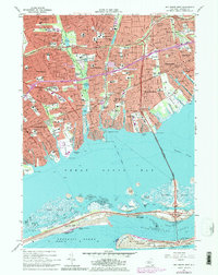
1969 Map of Bay Shore West
USGS Topo · Published 1979About this map
The Long Island Railroad cuts a straight path through this dense suburban landscape, anchoring the transit-oriented development of Babylon and Lindenhurst. The map reveals a post-war pattern of residential expansion, where local institutions like Our Lady of Lourdes Sch and Woods Road Sch serve established neighborhoods. Toward the shoreline, the Robert Moses Causeway bridges the Great South Bay, connecting the mainland to the barrier beach environments of Fire Island. This coastal geography is defined by narrow inlets and marshy islands such as Oak Island and Captree Island. Significant public green space is preserved at Belmont Lake State Park, while smaller water bodies like Southards Pond and Hawleys Lake are integrated into the suburban grid. The presence of the U S Coast Guard Station at Democrat Point underscores the area's strategic maritime importance at the Fire Island Inlet.
Find a feature on this map
105 named features on this map. Tap any name to fly to it.
Don’t see what you’re looking for? This feature index may not catch every label — zoom into the map to look around manually.
Map Details
Editions of this 1969 Bay Shore West Map
Other maps of this area

1901 · Babylon
USGS Topo · 1:62,500

1901 · Northport
USGS Topo · 1:62,500

1902 · Setauket
USGS Topo · 1:62,500

1902 · Fire Island
USGS Topo · 1:62,500

1903 · Babylon
USGS Topo · 1:62,500

1903 · Northport
USGS Topo · 1:62,500

1903 · Fire Island
USGS Topo · 1:62,500

1904 · Setauket
USGS Topo · 1:62,500

1904 · Islip
USGS Topo · 1:125,000

1919 · Setauket
USGS Topo · 1:62,500