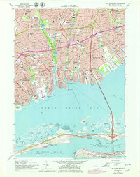
1969 Map of Bay Shore West
USGS Topo · Published 1979About this map
Great South Bay dominates this late-sixties perspective of the Suffolk County coastline, where the urban expansion of Babylon and Bay Shore meets the barrier islands of the Atlantic coast. The map illustrates a densely settled residential landscape punctuated by significant public works, including the Southern State Parkway and the sweeping Robert Moses Causeway connecting the mainland to Captree Island and Oak Beach. Cultural and religious landmarks are well-represented, from parochial institutions like Our Lady of Lourdes Sch to the grounds of Breslau Cem. Along the shore, numerous inlets such as Santapogue Creek and Sampawams Creek delineate the various necks of land, while the Long Island RR serves as the primary transit spine for the inland communities of Lindenhurst and Wyandanch. The presence of Belmont Lake State Park and Guggenheim Lakes highlights the intentional preservation of green space and freshwater features amidst the growing suburban grid.
Find a feature on this map
78 named features on this map. Tap any name to fly to it.
Don’t see what you’re looking for? This feature index may not catch every label — zoom into the map to look around manually.
Map Details
Editions of this 1969 Bay Shore West Map
Other maps of this area

1901 · Babylon
USGS Topo · 1:62,500

1901 · Northport
USGS Topo · 1:62,500

1902 · Setauket
USGS Topo · 1:62,500

1902 · Fire Island
USGS Topo · 1:62,500

1903 · Babylon
USGS Topo · 1:62,500

1903 · Northport
USGS Topo · 1:62,500

1903 · Fire Island
USGS Topo · 1:62,500

1904 · Setauket
USGS Topo · 1:62,500

1904 · Islip
USGS Topo · 1:125,000

1919 · Setauket
USGS Topo · 1:62,500