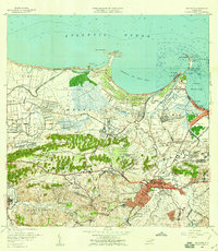
1957 Map of Bayamon
USGS Topo · Published 1959About this map
The growing urban core of Bayamón sits at the intersection of industry and coastal marshlands in this late 1950s survey. To the north, the U S Naval Reservation and U.S. Military Res dominate the landscape near Pta Salinas, while the Ensenada de Boca Vieja defines the coastline between Isla de las Palomas and the historical fortification site at Isla de Cabras. Inland, the agricultural roots of the region are still visible through the Central Juanita sugar mill and the sprawling plantation lands of Hato Tejas.
Find a feature on this map
111 named features on this map. Tap any name to fly to it.
Don’t see what you’re looking for? This feature index may not catch every label — zoom into the map to look around manually.
Map Details
Editions of this 1957 Bayamon Map
This is the sole edition of this map. No revisions or reprints were ever made.
Other maps of this area

1940 · Vega Alta
USGS Topo · 1:30,000

1941 · Bayamon
USGS Topo · 1:30,000

1941 · San Juan
USGS Topo · 1:30,000

1946 · Aguas Buenas
USGS Topo · 1:30,000

1946 · Corozal
USGS Topo · 1:30,000

1946 · Vega Alta
USGS Topo · 1:30,000

1946 · Naranjito
USGS Topo · 1:30,000
1947 · Corozal NE
USGS Topo · 1:10,000

1947 · Aguas Buenas NO
USGS Topo · 1:10,000

1947 · Bayamon
USGS Topo · 1:30,000