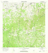
1970 Map of Bayaney
USGS Topo · Published 1973About this map
The Observatorio de Arecibo anchors the northeastern corner of this interior landscape, where the karst topography of northern Puerto Rico meets the central mountains. The terrain is defined by the deep incisions of the Río Camuy and Río Tanamá, which carve through various barrios including Bayaney, Angeles, and Caguana. This 1970 field-checked survey reveals a rural society structured around local education and faith, with numerous institutions like the Escuela Domingo Arana Márquez and the Iglesia Cristo Rey serving the dispersed population. Significant cultural heritage is represented at the Parque Ceremonial de Indígena Caguana near the banks of the Tanamá. Small settlements such as Matide and Milagros are connected by a network of winding roads that follow the ridges and valleys between Cerro Palma and Cerro La Torre.
Find a feature on this map
54 named features on this map. Tap any name to fly to it.
Don’t see what you’re looking for? This feature index may not catch every label — zoom into the map to look around manually.
Map Details
Editions of this 1970 Bayaney Map
3 editions found
Other maps of this area

1938 · Camuy
USGS Topo · 1:20,000

1938 · San Sebastian
USGS Topo · 1:20,000

1938 · Quebradillas
USGS Topo · 1:20,000

1941 · San Sebastian
USGS Topo · 1:30,000

1942 · Arecibo
USGS Topo · 1:30,000

1942 · Camuy
USGS Topo · 1:30,000

1946 · Maricao
USGS Topo · 1:30,000

1946 · Utuado
USGS Topo · 1:30,000

1946 · Bayaney
USGS Topo · 1:30,000

1946 · Monte Guilarte
USGS Topo · 1:30,000
Featured Places
- Sector El Calvario, Utuado
- Parcelas Miria, Lares
- Sector Los Cuevas, Utuado
- Sector Las Cuarenta, Hatillo
- Sector Los Santiagos, Lares