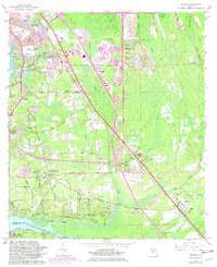
1964 Map of Bayard
USGS Topo · Published 1981About this map
St Johns River frontage and the path of the Florida East Coast railway dominate the landscape south of Jacksonville in this mid-century survey with revisions through 1981. The map documents a period of suburban transition, where established rural communities like Loretto and Bayard coexist with newer developments like the Wesley Manor Retirement Village and various country clubs. The inland terrain is defined by a complex network of wetlands, including Tiger Hole Swamp and Big Island Swamp, which hem in the cultivated lands and local roads. Significant local institutions are well-marked, including St Josephs Academy and Loretto Sch, alongside numerous neighborhood houses of worship such as Mt Zion Ch and New Allen Chapel. These settlements are linked by historic corridors like Old St Augustine Road, illustrating the area's growth patterns before more modern intensive urbanization.
Find a feature on this map
59 named features on this map. Tap any name to fly to it.
Don’t see what you’re looking for? This feature index may not catch every label — zoom into the map to look around manually.
Map Details
Editions of this 1964 Bayard Map
3 editions found
Other maps of this area

1917 · Orange Park
USGS Topo · 1:62,500

1918 · Jacksonville
USGS Topo · 1:62,500

1918 · Orange Park
USGS Topo · 1:62,500

1918 · Palm Valley
USGS Topo · 1:62,500

1918 · Mayport
USGS Topo · 1:62,500

1948 · Jacksonville
USGS Topo · 1:250,000

1948 · Jacksonville Beach
USGS Topo · 1:24,000

1949 · Jacksonville Beach
USGS Topo · 1:24,000

1950 · Arlington
USGS Topo · 1:24,000
1950 · Jacksonville
USGS Topo · 1:24,000
Featured Places
- Jacksonville, FL
- Greenland, Jacksonville
- San Jose, Jacksonville
- Bayard, Jacksonville
- Stockade, Jacksonville