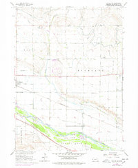
1965 Map of Bayard SW
USGS Topo · Published 1977About this map
Irrigation infrastructure and river-bottom agriculture dominate this landscape along the North Platte River during the mid-1960s. The region is defined by a dense network of man-made waterways, including the Tri-State Canal and Minatare Canal, which support the farming operations in Highland and Tabor. These water systems, coupled with the Union Pacific railroad corridor, shaped the development of local hubs like Minatare and McGrew.
Find a feature on this map
33 named features on this map. Tap any name to fly to it.
Don’t see what you’re looking for? This feature index may not catch every label — zoom into the map to look around manually.
Map Details
Editions of this 1965 Bayard SW Map
2 editions found
Other maps of this area

1898 · Scotts Bluff
USGS Topo · 1:125,000

1898 · Camp Clarke
USGS Topo · 1:125,000

1954 · Scottsbluff
USGS Topo · 1:250,000

1958 · Scottsbluff
USGS Topo · 1:250,000

1965 · Minatare
USGS Topo · 1:24,000

1965 · Bayard
USGS Topo · 1:24,000
1965 · Bayard NE
USGS Topo · 1:24,000

1965 · South Bayard
USGS Topo · 1:24,000
1965 · Lake Alice
USGS Topo · 1:24,000

1965 · Bayard SW
USGS Topo · 1:24,000