1951 Map of Beach Haven
USGS Topo · Published 1984About this map
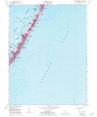
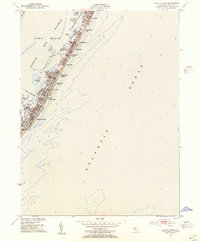
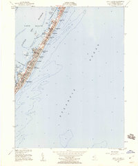
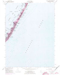
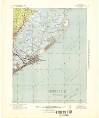
Long Beach barrier island serves as a slender buffer between the Atlantic Ocean and the sheltered waters of Little Egg Harbor in this mid-century portrait of coastal New Jersey. The settlement pattern is defined by a dense, linear progression of seasonal communities, including Beach Haven Crest, Brighton Beach, and Peahala Park. These neighborhoods are tightly packed along the shore, hemmed in by the Intracostal Waterway to the west. On the bay side, numerous small landforms such as Mordecai Island, Parker Island, and the Marshelder Islands break the surface, providing natural protection for Harris Harbor. The presence of the Boro Boundary at Beach Haven indicates the formal organization of these resort towns as they expanded during the post-war era, while the inclusion of a Sewage Disposal plant reflects the necessary infrastructure supporting this growing population on a delicate coastal strip.
Find a feature on this map
26 named features on this map. Tap any name to fly to it.
Don’t see what you’re looking for? This feature index may not catch every label — zoom into the map to look around manually.
Map Details
Editions of this 1951 Beach Haven Map
4 editions found
Other maps of this area

1887 · Atlantic City
USGS Topo · 1:62,500

1888 · Little Egg Harbor
USGS Topo · 1:62,500

1888 · Long Beach
USGS Topo · 1:62,500

1893 · Little Egg Harbor
USGS Topo · 1:62,500

1893 · Long Beach
USGS Topo · 1:62,500

1894 · Atlantic City
USGS Topo · 1:62,500

1919 · Long Beach
USGS Topo · 1:62,500

1920 · Little Egg Harbor
USGS Topo · 1:62,500

1940 · Atlantic City
USGS Topo · 1:62,500
1941 · Atlantic City
USGS Topo · 1:62,500