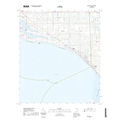
2021 Map of Beacon Hill
USGS Topo · Published 2021About this map
Mexico Beach and Beacon Hill anchor the coastline where the Bay Co Gulf Co line meets the Gulf of Mexico. This coastal landscape is defined by the narrow strip of development along Bay Rd and the intricate barrier features protecting the mainland, including Raffield Peninsula and Crooked Island. The geography transitions from the saltwater of Saint Andrew Sound to the dense, marshy interiors of Bear Swamp and Panther Swamp. Maritime activity is concentrated around the Intracoastal Waterway and the expansive Saint Joseph Bay to the southeast. A network of grid-patterned streets in the coastal settlements, such as Maryland Blvd and Georgia Ave, contrasts with the industrial and perimeter roads of the interior, such as Tyndall Perimeter Rd, reflecting the region's balance of residential retreat and coastal management.
Find a feature on this map
50 named features on this map. Tap any name to fly to it.
Don’t see what you’re looking for? This feature index may not catch every label — zoom into the map to look around manually.
Map Details
Editions of this 2021 Beacon Hill Map
This is the sole edition of this map. No revisions or reprints were ever made.
Other maps of this area

1943 · Port St. Joe
USGS Topo · 1:31,680

1943 · Overstreet
USGS Topo · 1:31,680

1943 · Crooked Island
USGS Topo · 1:31,680

1944 · Beacon Hill
USGS Topo · 1:31,680

1944 · Long Point
USGS Topo · 1:31,680

1945 · Allanton
USGS Topo · 1:31,680

1945 · Wetappo Creek
USGS Topo · 1:31,680

1945 · St Joseph Point
USGS Topo · 1:31,680

1947 · Allanton
USGS Topo · 1:25,000

1949 · Apalachicola
USGS Topo · 1:250,000