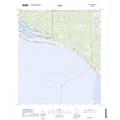
2024 Map of Beacon Hill
USGS Topo · Published 2024About this map
Tyndall Air Force Base occupies a significant portion of this coastal landscape, bordering the waters of Saint Andrew Sound and Wild Goose Lagoon. The map reveals a transition from military-managed wetlands to the residential layouts of Mexico Beach and Beacon Hill along the Gulf coast. Between these settlements, the shoreline is shaped by the Raffield Peninsula and Crooked Island, while the Intracoastal Waterway cuts through the northeast, facilitating maritime traffic behind the barrier system. Inland, the terrain is dominated by low-lying drainages including Bear Swamp, Panther Swamp, and Cypress Creek, illustrating the intricate hydrology of the Florida Panhandle. The coastal road network, featuring Canal Pkwy and Maryland Blvd, connects these waterfront communities, while the Florida Circumnavigational Paddling Trl follows the edge of the Gulf of Mexico.
Find a feature on this map
47 named features on this map. Tap any name to fly to it.
Don’t see what you’re looking for? This feature index may not catch every label — zoom into the map to look around manually.
Map Details
Editions of this 2024 Beacon Hill Map
This is the sole edition of this map. No revisions or reprints were ever made.
Other maps of this area

1943 · Port St. Joe
USGS Topo · 1:31,680

1943 · Overstreet
USGS Topo · 1:31,680

1943 · Crooked Island
USGS Topo · 1:31,680

1944 · Beacon Hill
USGS Topo · 1:31,680

1944 · Long Point
USGS Topo · 1:31,680

1945 · Allanton
USGS Topo · 1:31,680

1945 · Wetappo Creek
USGS Topo · 1:31,680

1945 · St Joseph Point
USGS Topo · 1:31,680

1947 · Allanton
USGS Topo · 1:25,000

1949 · Apalachicola
USGS Topo · 1:250,000