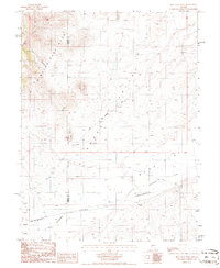
1986 Map of Bean Flat West
USGS Topo · Published 1986About this map
The Old Pony Express Trail cuts a historical diagonal across this mid-1980s landscape, tracing a path through the southern reaches of the Simpson Park Mountains. This central Nevada terrain is defined by the broad transition from the high ridges of Flat Canyon and The Point down into the expansive Kobeh Valley. In the lower elevations, the seasonal drainage of Stoneberger Creek winds toward Bean Flat, illustrating the typical Great Basin drainage patterns where water flows toward arid sinks rather than the sea.
Find a feature on this map
11 named features on this map. Tap any name to fly to it.
Don’t see what you’re looking for? This feature index may not catch every label — zoom into the map to look around manually.
Map Details
Editions of this 1986 Bean Flat West Map
This is the sole edition of this map. No revisions or reprints were ever made.
Other maps of this area

1926 · Roberts Mountains
USGS Topo · 1:250,000

1929 · Roberts Mountains
USGS Topo · 1:250,000

1955 · Millett
USGS Topo · 1:250,000

1956 · Bartine Ranch
USGS Topo · 1:62,500

1956 · Antelope Peak
USGS Topo · 1:62,500

1956 · Ackerman Canyon
USGS Topo · 1:62,500

1959 · Millett
USGS Topo · 1:250,000

1960 · Hickison Summit
USGS Topo · 1:62,500

1978 · Summit Mountain
USGS Topo · 1:100,000

1979 · Simpson Park Mtns
USGS Topo · 1:100,000