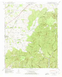
1948 Map of Beans Creek
USGS Topo · Published 1974About this map
The Nashville Chattanooga and St Louis railroad serves as a primary corridor through this section of Franklin County, linking the settlements of Belvidere and Maxwell. While the northern and western reaches of the sheet are defined by agricultural homesteads and numerous family burial grounds, such as Bridges Cem and Hatchett Cem, the eastern topography rises sharply into the complex ridges of Buncombe Ridge and Grassy Glade Ridge.
Find a feature on this map
88 named features on this map. Tap any name to fly to it.
Don’t see what you’re looking for? This feature index may not catch every label — zoom into the map to look around manually.
Map Details
Editions of this 1948 Beans Creek Map
2 editions found
Other maps of this area

1888 · Scottsboro
USGS Topo · 1:125,000

1892 · Scottsboro
USGS Topo · 1:125,000

1928 · Decherd
USGS Topo · 1:62,500

1936 · King Cove
USGS Topo · 1:24,000

1936 · Beans Creek
USGS Topo · 1:24,000

1936 · Hytop
USGS Topo · 1:24,000

1936 · Winchester
USGS Topo · 1:24,000

1936 · Huntland
USGS Topo · 1:24,000

1936 · Belvidere
USGS Topo · 1:24,000

1936 · Pitcher Ridge
USGS Topo · 1:24,000